

For years, divers, paddlers, and researchers have asked the same simple question: how deep is Australia’s deepest lake? Lake St Clair in Tasmania has held that title for a long time, but its true maximum depth was not confirmed with a complete modern survey.
CSIRO, Australia’s national science agency, has now mapped the entire lake at high resolution and confirmed the answer. The deepest point of Lake St Clair is 163 meters. This result ends a long period of uncertainty, when earlier estimates placed the maximum depth somewhere between 160 and 215 meters.
For experienced divers, a number like 163 meters stands out. Most divers will never go near this depth. But the story is not about record chasing. It is about what accurate mapping can reveal, and why it matters for safety, environmental work, and how we understand underwater landscapes.
Why Lake St Clair matters to divers and water users
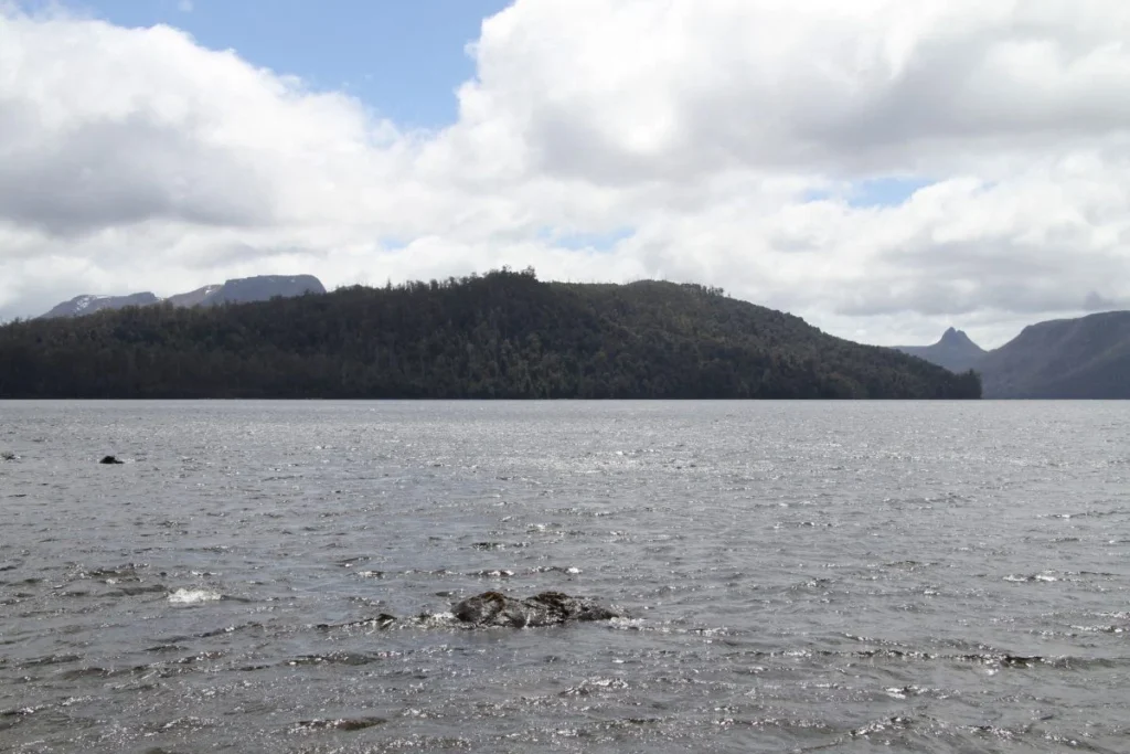
Lake St Clair sits in Tasmania’s central highlands and is part of the Cradle Mountain–Lake St Clair National Park, within a UNESCO World Heritage-listed area. It is widely known for rugged scenery and remote wilderness conditions.
From an experienced diver’s viewpoint, this type of setting has two clear themes:
- The underwater world can be complex even in “calm” inland water.
- Good data changes how people work on and around water.
Lake St Clair is not a reef system, and it is not the open ocean. But it still has steep slopes, channels, and hidden structure. Those features affect how water moves, how habitats form, and how safe operations can be for vessels and research teams.
The problem: no definitive maximum depth
It can seem surprising that a famous lake could go so long without a confirmed maximum depth. But measuring an entire lake in detail is not a simple weekend task. To confirm a true deepest point, a survey has to cover the whole water body in a consistent way, with instruments that can resolve small changes in bottom shape.
Before this project, Lake St Clair’s maximum depth had not been definitively measured. Estimates varied widely, and the upper range of 215 meters shows how uncertain the older numbers were.
For divers, this is a familiar lesson. Many underwater “facts” come from partial data, local reports, or older charts that were never designed for modern precision. Bathymetry is only as good as the survey behind it.
How CSIRO mapped the lake in high detail
Multibeam sonar for the lakebed
CSIRO’s team used multibeam sonar to measure depth across the lake. Multibeam systems send out many sound pulses in a fan shape and measure the time it takes for echoes to return from the bottom. This produces dense depth data, not just a single line of soundings.
In practical terms, multibeam sonar lets surveyors build a full picture of the lakebed, including steep drops and narrow features that older methods can miss.
LIDAR for the shoreline and shallow margins
To connect underwater data with the shoreline, the team also used Light Detection and Ranging (LIDAR). LIDAR helps build a detailed model of the shoreline shape and nearshore zones.
This matters because the edge of a lake is often where data quality breaks down. Shallow water can be hard for larger vessels to survey, and older charts may show simplified contours near land.
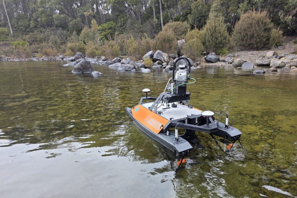
Two vessels working together: RV South Cape and the Otter
The survey used an eight-meter twin-hulled research vessel, RV South Cape, working alongside a smaller two-meter uncrewed surface vessel called the Otter.
This combination is important. Larger platforms can carry survey gear and work efficiently over deeper water. Smaller uncrewed vessels can safely work in shallow areas that are difficult or risky for a bigger boat. In experienced dive terms, it is like choosing the right tool for the right part of the site.
Eight days of surveying in hard conditions
CSIRO reported that the team surveyed the lake over eight days, working through challenging weather. This point is easy to overlook, but it is often the difference between a partial survey and a complete one. Consistent coverage, in varied conditions, is what creates a map you can trust.
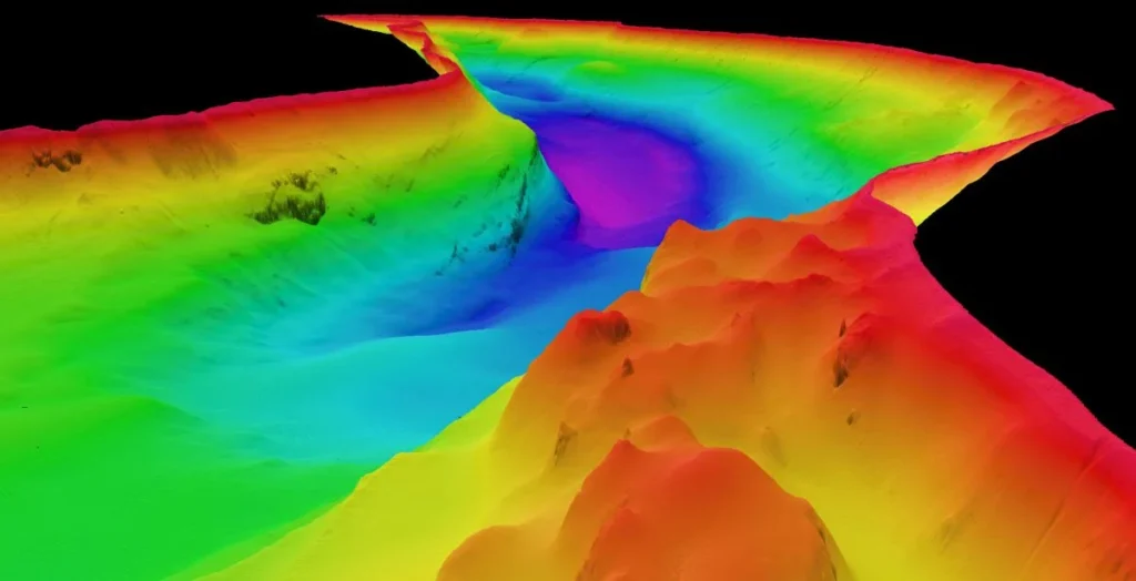
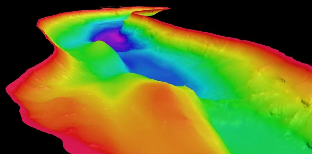
What the survey found under the surface
High-resolution mapping showed Lake St Clair is not a simple bowl-shaped lake. The lakebed includes:
- Steep submerged cliffs
- Deep channels
- Large rock structures hidden below the surface
For experienced divers, this description matches what you might expect in a landscape shaped by strong forces. Lake St Clair was formed by glaciers that carved through surrounding bedrock. When glaciers shape a basin, they can leave sharp edges, deep troughs, and abrupt transitions between shallow shelves and deeper sections.
This has practical meaning for anyone working on the water. A lake with steep underwater cliffs and channels is not the same as a lake with gentle slopes. It affects anchoring decisions, search planning, and research sampling design.
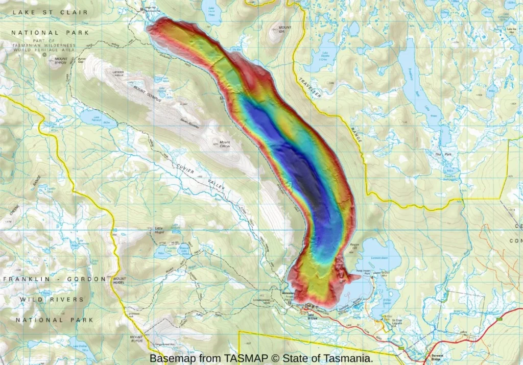
The confirmed result: 163 meters, with more deep areas than expected
The key finding is the confirmed maximum depth: 163 meters.
CSIRO’s hydrographic surveyor Augustin Déplante explained that the deepest point sits close to the western shore, on a bend in the lake about 4 kilometers north of the visitor centre. He also noted there are several areas where depth reaches 150 meters.
This detail is important. It suggests the lake has multiple deep zones, not just one isolated “pit.” For environmental science, that can influence how water layers form and where different habitats may exist. For operations, it helps identify areas where deep-water testing and monitoring could take place.
CSIRO also compared the lake’s depth to Bass Strait, stating that Bass Strait reaches a maximum depth of about 85 meters. The comparison helps put the number into context. Lake St Clair’s deepest point is almost twice that depth.
Why this mapping matters beyond the depth number
Better tools for ecology and habitat research
CSIRO plans to make the full three-dimensional dataset available to researchers, environmental managers, and other stakeholders. For science teams, a detailed lakebed and shoreline model supports stronger study design. Sampling locations can be selected with clear knowledge of bottom shape and underwater terrain.
For divers involved in research support, that kind of dataset can reduce guesswork and improve safety planning. It also helps teams track changes over time if future surveys repeat the work.
Safer operations for vessels on the lake
High-resolution mapping can support safer vessel operations, especially where shallow margins, rock structures, or steep slopes create navigational risk.
Even if most recreational users do not need a full 3D model, accurate maps help managers and operators understand where risk zones are likely to be.
A platform for testing autonomous systems
CSIRO noted the mapping may support future experiments, including testing autonomous underwater vehicles. A controlled but complex environment like Lake St Clair can be valuable for testing new systems that need accurate ground truth data.
The diver’s takeaway: data is part of good water practice
Experienced divers know that depth is not a single number. It is a profile, a set of contours, and a set of conditions. Lake St Clair’s newly confirmed 163-meter maximum depth is interesting, but the real value is the full high-resolution model behind it.
This project also shows why combining tools matters. Multibeam sonar, LIDAR, and uncrewed vessels each solve different problems. Together, they reduce blind spots and produce a single integrated model that is useful for science and management.
Finally, it is a reminder that inland waters can hold serious depth and serious terrain. Even in a lake, the underwater landscape can include cliffs, channels, and complex structure that would surprise anyone who only sees the surface.
Conclusion
CSIRO’s new high-resolution mapping of Lake St Clair has confirmed a clear answer: Australia’s deepest lake reaches 163 meters at its deepest point. The survey also revealed steep underwater cliffs, deep channels, and large rock structures shaped by glacial history. Beyond the headline depth figure, the project delivers a detailed 3D dataset that can support ecological research, safer operations on the lake, and future work with autonomous systems. For experienced divers, it is a strong example of how modern mapping turns “known” places into understood places.

A young voice whose articles shine with energy and a fresh perspective. Through a promising pen, he takes us on journeys driven by a passion for discovery and a spirit of curiosity, adding a distinctive character to Diventures that reflects a new generation of writers connected to the sea and its worlds.